
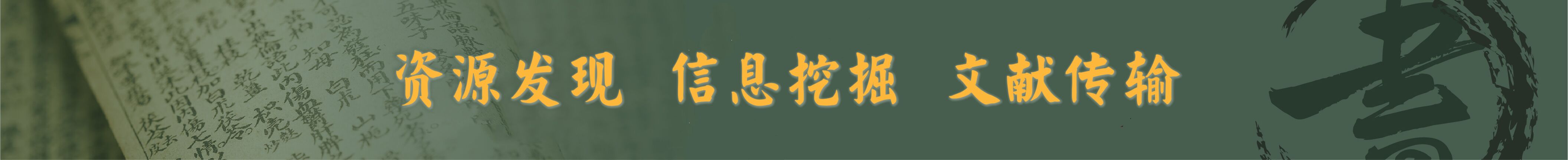
61、 Maris Pacifici (quod vulgò Mar del Zur) cum regionibus circumiacentibus insulisque in eodem passim sparsis, novissima descriptio
CollectionAntique Maps of China Map makersOrtelius, Abraham, 1527-1598 Geographic regionPacific Ocean NoteScale ca 1:41,000,000 LanguageLatin Call numberG9230 1589 O7 DOI10 14711/spcol/b536695...
更多: 京东 国图 籍合网 知网万方 万方数据 孔夫子旧书网 国图▪文津 上海图书馆

62、 Chinae, olim sinarum regionis, nova descriptio
CollectionAntique Maps of China Map makers Ortelius, Abraham, 1527-1598 Barbuda, Luis Jorge de, active 1575-1599 Geographic region China 中國 Additional titles A new map of China, once called the Region of the Sinae 中國新圖 Note Scale indeter...
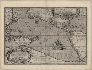
63、 Exacta et accurata delineatio cùm orarum maritimarum tùm etjam locorum terrestrium qvae in regionibus China ..
CollectionAntique Maps of China Map makersLinschoten, Jan Huygen van, 1563-1611 SubjectsNautical charts Geographic region Southeast Asia China Sea Note Scale ca 2 cm = 35 German miles Relief shown pictorially Oriented with North to the lef...
更多: 上海图书馆 京东 万方数据 籍合网 孔夫子旧书网 抗日战争与近代中日关系文献数据平台 国图 国图▪文津 知网万方

64、 Regnum Chinae
CollectionAntique Maps of China Map makersBotero, Giovanni, 1540-1617 SubjectsMaps Geographic region China 中國 Additional titles Kingdom of China 中華帝國 Note Scale indeterminable Title from "China in European maps", p 158:中華帝國=The Kingdom of...
更多: 知网万方 上海图书馆 国图▪文津 万方数据 籍合网 国图 抗日战争与近代中日关系文献数据平台 孔夫子旧书网

65、 China regio Asie
CollectionAntique Maps of China Map makersBotero, Giovanni, 1540-1617 Subjects Maps Early maps Geographic regionChina Note Scale not given Relief shown pictorially At head of map: Libro secondo, re della China At right top: 89 Text on ver...
更多: 抗日战争与近代中日关系文献数据平台 万方数据 知网万方 孔夫子旧书网 京东 国图▪文津 上海图书馆 国图 籍合网

66、 China regio Asiæ
CollectionAntique Maps of China Map makers Ortelius, Abraham, 1527-1598 Ortelius, Abraham, 1527-1598 German SubjectsMaps Geographic region China Asia Additional titles At top of map: China Epitome Note Scale not given (E 120°--E 170°/N 6...
更多: 抗日战争与近代中日关系文献数据平台 万方数据 知网万方 国图▪文津 籍合网 孔夫子旧书网 上海图书馆 国图 京东
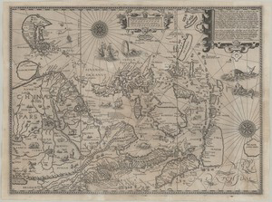
67、 The map of China
CollectionAntique Maps of China Map makersPurchas, Samuel, 1575 -1626 Geographic regionChina Additional titles皇明一统方輿備覧 Note Scale not given (E102°--E145°/N 45°--N 15°) Title also in Chinese: Huang Ming yi tong fang yu bei lan First publishe...
更多: 万方数据 抗日战争与近代中日关系文献数据平台 京东 国图▪文津 上海图书馆

68、 China
CollectionAntique Maps of China Map makers Mercator, Gerhard, 1512-1594 Hondius, Jodocus, 1563-1612 Keere, Pieter van den, 1571-approximately 1646 Subjects Maps Early maps lcgft Geographic regionChina Additional titlesRoyaume de la Chine ...
更多: 上海图书馆 万方数据 国图▪文津 抗日战争与近代中日关系文献数据平台 国图 孔夫子旧书网 知网万方 籍合网
69、 China veteribus sinarum regio nunc incolis tame dicta
CollectionAntique Maps of China Map makers Merian, Matthaeus, 1593-1650 Gottfried, Johann Ludwig, active 17th century Subjects Maps Early maps lcgft Geographic regionChina Additional titlesHistorische chronica Note Scale [ca 1:18,500,000]...
更多: 国图 孔夫子旧书网 上海图书馆 万方数据 抗日战争与近代中日关系文献数据平台 知网万方

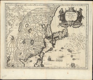
70、 China veteribus Sinarum Regio nunc Incolis Tame dicta
CollectionAntique Maps of China Map makers Blaeu, Willem Janszoon, 1571-1638 Blaeu, Joan, 1596-1673 Geographic region China Japan Korea East Asia 中國 Note Scale [ca 1:11,750,000] Relief shown pictorially Map first printed in 1635 Dedicatio...
更多: 京东 万方数据 孔夫子旧书网 上海图书馆 国图 知网万方 国图▪文津
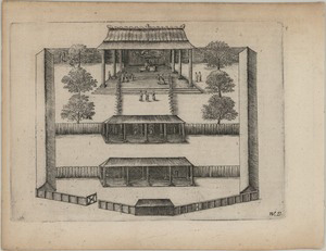
71、 Afbeeldinghe van t'Paleis van Lamthau op de Riviere van Canton aen de Noordzyde gelyk den Secretaries daer den Mandorijn gesproken heest
CollectionAntique Maps of China Map makersCommelin, Isaac, 1598-1676 Subjects Palaces Pictorial works Geographic region Hong Kong Lantau (Hong Kong, China) Lantau 香港 南嶼島 中國 Additional titlesIllustration of the Palace at Lamthau on the Nor...
更多: 上海图书馆 孔夫子旧书网 籍合网 万方数据 国图▪文津 国图 京东

72、 Carta particolare del mare di Cocincina con la parte Australe della China
CollectionAntique Maps of China Map makers Dudley, Robert, Sir, 1574-1649 Lucini, Antonio Francesco, b 1605 SubjectsCoasts Geographic region China, Southeast Vietnam 東南部(中國) Note Scale not given (E 137°--E 149°/N 26°--N 12°302) "A F Lucin...
更多: 上海图书馆 国图 知网万方 国图▪文津 籍合网 万方数据

73、 Maccauw
CollectionAntique Maps of China Map makersCommelin, Isaac, 1598-1676 SubjectsPictorial works Geographic region Macau (China : Special Administrative Region) Macau 澳門 NoteAppeared in: Commelin s Begin ende Voortgangh, v 2 LanguageDutch Call...
更多: 万方数据 国图▪文津 抗日战争与近代中日关系文献数据平台 京东 国图 籍合网 知网万方 孔夫子旧书网 上海图书馆

74、 Description de la Tartarie
CollectionAntique Maps of China Map makersSanson, N (Nicolas), 1626-1648 Subjects Discoveries in geography Maps Discovery and exploration Geographic regionRussia Note Scale indeterminable Relief shown pictorially Hand colored "Tiree en pa...
更多: 知网万方 国图▪文津 万方数据 上海图书馆 京东 国图 籍合网 抗日战争与近代中日关系文献数据平台

75、 Honan imperii sinarum provincia quinta
CollectionAntique Maps of China Map makers Blaeu, Joan, 1596-1673 Martini, Martino, 1614-1661 Geographic region China Henan 中國 河南 Note Scale ca 1 cm = 2 German miles Relief shown pictorially Hand colored Appeared in: Martini s Atlas sinen...
更多: 国图▪文津 知网万方 上海图书馆 籍合网 孔夫子旧书网 万方数据


77、 Nanking, sive Kiangnan : imperii sinarum provincia nona
CollectionAntique Maps of China Map makersBlaeu, Joan, 1596-1673 Geographic region Jiangsu Anhui Note Scale ca 1 cm = 3 German miles Relief shown pictorially Hand colored Appeared in: Martini s Atlas sinensis, between pp 94-95 Call number...
更多: 上海图书馆 万方数据 国图 国图▪文津 京东 知网万方 籍合网 孔夫子旧书网 抗日战争与近代中日关系文献数据平台

78、 Novus atlas sinensis
CollectionAntique Maps of China Map makers Martini, Martino, 1614-1661 Blaeu, Joan, 1596-1673 SubjectsDescription and travel Geographic region China 中國 Additional titlesAtlas maior V 10 Note Contains 17 maps: 1 of China and Japan, 1 of Ja...
更多: 知网万方 国图▪文津 京东 籍合网 孔夫子旧书网 国图 万方数据

79、 Quantung : imperii sinarum provincia duodecima
CollectionAntique Maps of China Map makersBlaeu, Joan, 1596-1673 Geographic regionGuangdong Note Scale ca 1 cm = 3 45 German miles Relief shown pictorially Hand colored Appeared in: Martini s Atlas sinensis, between pp 132-133 Call numberG...
更多: 孔夫子旧书网 抗日战争与近代中日关系文献数据平台 知网万方 京东 国图▪文津

80、 Queicheu : imperii sinarum provincia decimaquarta
CollectionAntique Maps of China Map makersBlaeu, Joan, 1596-1673 Geographic regionGuizhou Note Scale ca 1 cm = 1 8 German miles Relief shown pictorially Hand colored Appeared in: Martini s Atlas sinensis, between pp 148-149 Call numberG230...
更多: 国图 知网万方 国图▪文津 京东 籍合网 万方数据 孔夫子旧书网