


81、 Xantung sinarum imperii provincia quarta
CollectionAntique Maps of China Map makers Blaeu, Joan, 1596-1673 Martini, Martino, 1614-1661 Geographic region China Shandong 中國 山東 Note Scale ca 2 cm = 5 German miles Relief shown pictorially Hand colored Appeared in: Martini s Atlas si...
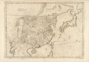
82、 Imperii Sinarvm nova descriptio
CollectionAntique Maps of China Map makersThévenot, Melchisédec, 1620-1692 SubjectsMaps Geographic regionChina Additional titles Imperii Sinarum nova descriptio Relations de divers voyages cvrievx Note Scale not given (E 115°--E 175°/N 4...

83、 De stadt Aymuy la ville d'Aymuy, dans la Chine
CollectionAntique Maps of China Map makersAa, Pieter van der, 1659-1733 Subjects Pictorial works Harbors Geographic region Xiamen (Fujian, China) Xiamen (Fujian) Fujian Xiamen 廈門市 福建 中國 Additional titlesVille d Aymuy, dans la Chine Langua...
更多: 籍合网 万方数据 京东 孔夫子旧书网 国图 上海图书馆
84、 Le roiaume de la Chine, et ses provinces
CollectionAntique Maps of China Map makersDuVal, P (Pierre) Geographic region China 中國 Note Scale not given (E 140°--E 180°/N 45°--N 18°302) Relief shown pictorially Includes descriptive text Hand colored LanguageFrench Call numberG7820 1...
更多: 上海图书馆 抗日战争与近代中日关系文献数据平台 京东 国图 孔夫子旧书网 万方数据 籍合网 知网万方

85、 The kingdome of China
CollectionAntique Maps of China Map makers Speed, John, 1552 -1629 Bassett, Thomas, bookseller Chiswell, Richard Geographic region China 中國 Note Scale ca 1:13,000,000 "newly augmented by I S , 1626 " Relief shown pictorially Hand colored ...
更多: 国图▪文津 知网万方 籍合网 抗日战争与近代中日关系文献数据平台 万方数据 孔夫子旧书网 京东 国图

86、 La Chine Royaume ..
CollectionAntique Maps of China Map makersSanson, Nicolas, 1600-1667 Geographic region China 中國 Note Scale [ca 1:9,500,000] (E 126°--E 170°/N 52°--N 18°) Relief shown pictorially Hand colored "Ceste carte n est quin abregé d une autre tres...
更多: 国图▪文津 知网万方 籍合网 万方数据 国图 京东 上海图书馆 孔夫子旧书网
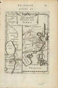
87、 Ancienne region des Sines
CollectionAntique Maps of China Map makersManesson-Mallet, Allain, 1630 -1706 SubjectsMaps Geographic region Asia China Additional titlesDescription de l univers Note Scales not given (E 129°--E 165°/N 48°--S 5°) Relief shown pictorially...
更多: 万方数据 知网万方 抗日战争与近代中日关系文献数据平台 上海图书馆 京东 国图 孔夫子旧书网

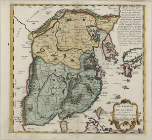
88、 Royaume de la Chine
CollectionAntique Maps of China Map makersSanson, Nicolas, 1600-1667 SubjectsMaps Geographic regionChina Note Scale approximately 1:15,000,000 Relief shown pictorially Map of the Chinese empire showing major cities and places Call numberG...
更多: 京东 孔夫子旧书网 国图 上海图书馆 万方数据 国图▪文津 籍合网 知网万方

89、 A large draught of the north part of China : shewing all the passages and chanells into the harbour of Chusan
CollectionAntique Maps of China Map makersThornton, John, fl 1658-1698 SubjectsNautical charts Geographic region China Zhoushan Qundao (Zhejiang) Zhoushan Qundao (Zhejiang, China) Zhejiang Zhoushan Qundao Additional titlesHarbour of Chusan...
更多: 孔夫子旧书网 抗日战争与近代中日关系文献数据平台 知网万方 国图▪文津 京东 上海图书馆 籍合网 万方数据 国图

90、 La Chine
CollectionAntique Maps of China Map makersFer, Nicolas de, 1646-1720 SubjectsMaps Geographic regionChina Note Scale not determined (E145°--E 175°/N 40°--N 20°) Relief shown pictorially At left top corner: T II p 94 Call numberG7820 1685 F...
更多: 国图▪文津 抗日战争与近代中日关系文献数据平台 孔夫子旧书网 知网万方 籍合网 万方数据 京东 上海图书馆 国图
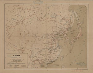
91、 General map of China and adjacent regions, showing treaty ports and railways
CollectionMaps of China, Late Qing Dynasty-1949 Map makersGeological Survey (U S ) Topographic Branch Subjects Harbors Railroads Geographic region China East Asia Note Scale 1:10,000,000 1 in = 157 8 miles 1 cm = 100 km ; Lambert conforma...
更多: 上海图书馆 知网万方 京东 国图▪文津 抗日战争与近代中日关系文献数据平台 孔夫子旧书网 国图 万方数据

93、 Map of China
CollectionMaps of China, Late Qing Dynasty-1949 Geographic region China 中國 Additional titlesChina handbook Note Scale 1:7,500,000 (E 70°--E 145°/N 45°--N 20°) Reprint China handbook, 1937-1945 Includes insets: China physical -- South China...
更多: 国图▪文津 孔夫子旧书网 上海图书馆 京东 抗日战争与近代中日关系文献数据平台 知网万方 籍合网

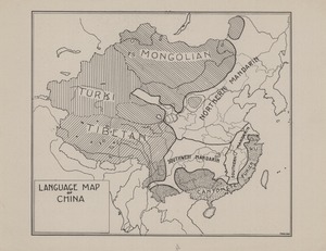
94、 Map of China showing the distribution of the missionary body
CollectionMaps of China, Late Qing Dynasty-1949 Map makers China Continuation Committee China Inland Mission Subjects Missions Geography Geographic region China 中國 Additional titles Maps of China New maps of China Note Scale 1:6,000,00...
更多: 知网万方 籍合网 国图▪文津 上海图书馆 孔夫子旧书网

95、 Tahiti et Moorea Océan Pacifique
CollectionMaps of China, Late Qing Dynasty-1949 Map makersFrance Dépôt des cartes et plans de la marine SubjectsMaps Geographic region Tahiti (French Polynesia : Island) Moorea (French Polynesia) Note Scale 1:100,870 "3500 " LanguageFrenc...
更多: 国图▪文津 京东 上海图书馆 籍合网 孔夫子旧书网 国图

96、 上海市道路系統圖. 閘北區
CollectionMaps of China, Late Qing Dynasty-1949 SubjectsRoads Geographic region 閘北區 (上海) Zhabei Qu (Shanghai) NoteScale [ca 1:7,143] LanguageChinese Call numberG7824 S2:3Z3P2 1934 S5 DOI10 14711/spcol/b1185666...
更多: 籍合网 抗日战争与近代中日关系文献数据平台 京东 国图 孔夫子旧书网 国图▪文津 知网万方


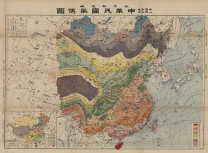
98、 中華民國人口種族分佈圖
CollectionMaps of China, Late Qing Dynasty-1949 Map makers 陸先鑑 陸殿揚 金擎宇 中國史地圖表編纂社 中國 教育部 Subjects Population Ethnology Geographic regionChina Note Scale 1:8,000,000 (E65°--E145°/N45°--N20°) "中心國民學校適用" LanguageChinese Call numberG7821 E2 1...
更多: 京东 孔夫子旧书网 抗日战争与近代中日关系文献数据平台 万方数据 知网万方 国图

99、 中華民國地形圖
CollectionMaps of China, Late Qing Dynasty-1949 Map makers 陸承蔭 陸殿揚 金擎宇 中國史地圖表編纂社 中國 教育部 SubjectsMaps, Physical Geographic regionChina Note Scale 1:8,000,000 (E65°--E145°/N45°--N20°) "中心國民學校適用" LanguageChinese Call numberG7821 C2 1947 L8 D...
更多: 抗日战争与近代中日关系文献数据平台 上海图书馆 国图▪文津 万方数据 籍合网 孔夫子旧书网 国图
100、 中華民國氣候圖
CollectionMaps of China, Late Qing Dynasty-1949 Map makers 金立煌 陸殿揚 金擎宇 中國史地圖表編纂社 中國 教育部 SubjectsClimate Geographic region China 中國 NoteScale 1:8,000,000 (E65°--E145°/N45°--N20°) LanguageChinese Call numberG7821 C8 1947 J56 DOI10 14711/spc...
更多: 知网万方 抗日战争与近代中日关系文献数据平台 籍合网 国图▪文津 上海图书馆 万方数据 国图